Monday, September 8, 2008

Grand Trunk Road

The Grand Trunk Road (commonly abbreviated to GT Road) is one of South Asia's oldest and longest major roads. For several centuries, it has linked the eastern and western regions of the Indian subcontinent, running from Bengal, across north India, into Peshawar in Pakistan.

Route

Today, the Grand Trunk Road remains a continuum that covers a distance of over 2,500 km. From its origin at Sonargaon in the Narayanganj District of central Bangladesh, it reaches India, passing through Kolkata, Bardhaman, Durgapur, Asansol, Varanasi, Allahabad, Kanpur, Aligarh, Delhi, Karnal, Ambala, Ludhiana,Jalandhar, Amritsar. Within India, the major portion of the road – the stretch between Kanpur and Kolkata – is known as NH-2 (National Highway - 2), the stretch between Kanpur and Delhi is called NH-91 (National Highway - 91), and that between Delhi and Wagah, at the border with Pakistan, is known as NH-1.

From the Pakistan border the Grand Trunk Road continues north through Lahore via Gujranwala, Gujrat, Jhelum, Rawalpindi, Attock District and Nowshera before it finally reaches Peshawar.

Historical Development of the Indian National Highways

In ancient times the ruling monarchs had established brick-laden roads in their cities. The most famous highway of medieval India was the Grand Trunk Road. The Grand Trunk Road begins in Sonargaon near Dhaka, Bangladesh and ends in Peshawar, Pakistan. It travels through important Indian cities and route such as Patna, Varanasi, Kanpur, Agra, Delhi, Panipat, Pipli, Ambala, Rajpura, Ludhiana, Jalandhar and Amritsar. In the 19th century, the British upgraded the highway network along with building roads in treacherous terrains such as the Western Ghats. The National Highways Authority of India (NHAI) is the national authority for the management of a network of over 6,000 km of National Highways in India.

Background: The NHAI was created with the promulagation of the National Highways Authority of India Act, 1988. The Authority was formally made operational in February 1995 as an autonomous body. It succeeds the previous Ministry of Surface Transport.

Mile by Mile, India Paves a Smoother Road to Its Future

NEW DELHI, India - In the middle of the old Grand Trunk Road a temple sits under a peepul tree. The surrounding highway is being widened to four lanes, and vehicles barrel along either side. But the temple and tree thwart even greater speed, and a passing contractor says they soon will be removed.

Kali, Hindu goddess of destruction, thinks otherwise. She is angry, say the colorfully garbed women massing in the holy tree's dappled shade. As evidence, they point to one woman's newly pockmarked face and other mysterious ailments recently visited on their nearby village, Jagdishrai. They have tried to convince Kali that the tree and temple devoted to her must go, but they have failed. Now they have no choice but to oppose the removal, too, even if they must block the road to do it.

Goddess versus man, superstition versus progress, the people versus the state - mile by mile, India is struggling to modernize its national highway system, and in the process, itself.

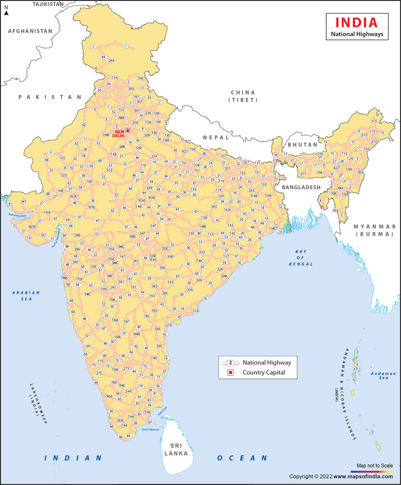
The Indian government has begun a 15-year project to widen and pave some 40,000 miles of narrow, decrepit national highways, with the first leg, budgeted at $6.25 billion, to be largely complete by next year. It amounts to the most ambitious infrastructure project since independence in 1947 and the British building of the subcontinent's railway network the century before.

The effort echoes the United States' construction of its national highway system in the 1920's and 1950's. The arteries paved across America fueled commerce and development, fed a nation's auto obsession and created suburbs. They also displaced communities and helped sap mass transit and deplete inner cities.

For India, already one of the world's fastest-growing economies and most rapidly evolving societies, the results may be as radical. At its heart, the redone highway is about grafting Western notions of speed and efficiency onto a civilization that has always taken the long view.

Aryan migration, Mogul conquest, British colonialism - all shaped India's civilization over centuries. Now, in a span of less than 15 years, capitalism and globalization have convulsed India at an unprecedented rate of change.

The real start came in 1991, when India began dismantling its state-run economy and opening its markets to foreign imports and investment. While that reform process has been fitful, leaving the country trailing its neighbor and rival, China, India has turned a corner. Its economy grew 6.9 percent in the fiscal year ending in March. India has a new identity, thanks to outsourcing, as back office to the world.

The new highway is certain to jump-start India's competitiveness, given that its dismal infrastructure helped keep it behind the economic success stories of the Asian Tigers.

"The perception of India earlier was that it cannot be in the rank of other fast-growing nations," said Sudheendra Kulkarni, who was an aide to Atal Bihari Vajpayee, the former prime minister who championed the project. With the highway, Mr. Kulkarni said, "People began to see that India is transforming."

To grasp that transformation, and India's transition, a New York Times reporter and photographer spent a month this year driving the first stage of the highway project, which has been dubbed, in awkward but bullish coinage, the Golden Quadrilateral.

More jagged than geometric, the four- and six-lane quadrilateral's 3,625 miles run through 13 states and India's four largest cities: New Delhi, Calcutta, Chennai, formerly Madras, and Mumbai, formerly Bombay. The journey along the highway offered a before-and-after snapshot of India, of the challenges of developing the world's largest democracy, and of how westernization is reshaping Indian society.

To drive east from New Delhi to Calcutta is to travel through flat fields, almost primeval forests, lush rice paddies - and some of India's poorest, roughest states, where contractors have battled violence and corruption to get the road built.

To move south from Calcutta, alongside the Bay of Bengal, through palm-covered hills, then up the west into Rajasthan's desert, is to see the highway as a conduit for the forces molding the new India. Ever-flashier cars, evidence of a frenzied new consumerism, leave bullock carts in the dust. Truckers slow at night for roadside sex workers, each of them potential carriers of H.I.V. Farmers' sons make a beeline for swelling cities that are challenging the village as the center of Indian life.

Important Highways

NH 24: National Highway24 is the designation of the Delhi-Lucknow National Highway in India. It is 438 kilometers in length and runs from Delhi to Lucknow.

NH 3: National Highway 3, commonly referred as Mumbai- Agra Road, is an busy freeway that runs through of Maharashtra, Madhya Pradesh, Rajasthan and Uttar Pradesh states in India. The freeway touches the cities of Agra in Uttar Pradesh, Dhaulpur in Rajasthan, Gwalior, Shivpuri, Guna, Biaora, Maksi & Indore in Madhya Pradesh, and Dhule, Nashik, Thane & Mumbai, in Maharashtra.The road is the part of National Highway network of India, and it is officially listed as running over 1161 Km from Agra to Mumbai.

NH4-Mumbai-Chennai HighwayNational Highway 4: National Highway 4 is the highway between Mumbai and Chennai. The highway passes through Bangalore and Pune and is also one of the busiest highways in India. This highway is part of the Indian government`s Golden Quadrilateral Project.

Indian National Highway 8: National Highway 8 is the major commercial Road that connects Mumbai with New Delhi. The highway passes through the state capitals of Gandhinagar and Jaipur, as well as important places like Ahmedabad, Surat and Vadodara.This highway is also part of the Indian government`s Golden Quadrilateral Project.

National Highway 17: NH 17 is a highway connecting Mumbai to Ernakulam. It starts at Panvel, at junction of National Highway 4, and ends at Edappally, near Ernakulam. National Highway 17 mainly passes through the west coast of India, sometimes touching shores of Arabian sea. The National Highway 17 touches the Arabian sea at Marvanthe in Karnataka. It passes through the Indian states of Maharastra, Goa, Karnataka and Kerala.

The National Highway 17 connects cities and towns of different states as follows: Mumbai, Ratnagiri, Panaji, Madgaon, Karwar, Kumta, Udupi, Surathkal, Mangaluru, Kasargod, Kannur, Kozhikkode and Ernakulam. The National Highway 17 connects the interior parts of coastal regions with rest of the country. The National Highway 17 connects major sea ports of Mumbai, JNPT, Mormugoa, New Mangalore ( NMPT ) and Cochin. The Highway was the only source of connection between areas in the coastal districts, until the Konkan Railway was opened in 1998, between Mumbai and Mangalore.

NH 47: National Highway 47, commonly referred to as NH 47, is an exteremely busy highway that runs through some parts of Tamil Nadu and the south-west coast of Kerala state in India. The highway touches the cities of Salem, Coimbatore, Palakkad, Trichur, Cochin, Kollam all the way to the southern tip of India around Thiruvananthapuram (Trivandrum). It is easily reachable to most residents of Western Kerala, and runs within a few kilometers of Cochin International Airport, located in Nedumbassery, and another international airport, Trivandrum International Airport in the city of Thiruvananthapuram. The road is the part of National Highway network of India, and it is officially listed as running over 650 Km from Salem to Kanyakumari.

NH 48: National Highway 48 connects Mangalore city with Bangalore city. The highway connects two major cities of Karnataka state of India.This national highway passes through towns of Nelamangala, Kunigal, Hassan, Sakleshpura, Uppinaangadi and B.C.Road. The traffic on this highway has increased phenomenally after 1990 A.D due to boom in IT jobs at Bangalore and setting up of MRPL at Katipalla. Large number of IT professionals working in Bangalore belong to Dakshina Kannada and Udupi districts.The goverment undertaking KSRTC runs several buses day and night in between these two cities along with private operators.

National Highway 47 (India)

National Highway 47, commonly referred to as NH 47, is a busy highway that runs through some parts of Tamil Nadu and the south-west coast of Kerala state in India. The highway touches the cities of Salem, Avinashi, Coimbatore, Palakkad, Trichur, Cochin, Kollam all the way to the southern tip of India around Thiruvananthapuram (Trivandrum). It is easily accessible to most residents of Western Kerala, and runs within a few kilometers of Cochin International Airport, located in Nedumbassery, and another international airport, Trivandrum International Airport in the city of Thiruvananthapuram and Coimbatore airport. The road is the part of National Highway network of India, and it is officially listed as running over 650 km (390 miles) from Salem to Kanyakumari (both in Tamil Nadu).

Traffic

NH 47 is subject to high volumes of traffic like NH45, often bumper-to-bumper. The highway has many stores and restaurants bordering it including some of the best dosai stands in all of India. Traffic is especially gridlocked as the road runs through the city of Coimbatore.

Towns connected

Kanyakumari, Padmanabhapuram, Nagercoil, Thukalay, Kaliyikkavilai, Parassala, Neyyattinkara, Thiruvananthapuram city, Kazhakkuttam, Attingal, Chathannur, Kottayam, Kollam, Karunagappally, Kayamkulam, Haripad, Ambalappuzha, Alappuzha, Cherthala (bypass), Aroor, Ernakulam (bypass), Kalamassery, Aluva, Angamali, Chalakkudy, Thrissur (bypass), Mannuthi, Vadakkanchery, Alathur, Palakkad (bypass), Walayar(Coimbatore District Border), Madukkarai, Kuniyamuthur, Coimbatore (bypass), Neelambur, Kaniyur, Karumathampatti, Avinashi, Perumanallur(Coimbatore District), Bhavani, Perunthurai, Sankari, and Salem.

Status

Though the Government of India is investing in widening the National Highways, NH47 is predominantly a two-lane highway for most parts. The stretch from Angamaly (in Ernakulam District) to Cherthala (in Alappuzha District) is almost completely four-laned along the Bypass to Ernakulam City. However, the junction at Edappally with NH-17(which runs to Mumbai via Kozhikkode, Mangalore and Goa) is a very congested junction. The road Widening has started at the Salem End of the Highway and the 4 laning work is 70% finished in the Salem-Sankari stretch and there is a new bridge is being built on the Cauvery river at Bhavani Kooduthurai. and many fly overs are comming up in many places. Widening is in progress from Walayar (Kerala- Tamil Nadu Border, Palakkad District, Kerala) to Angamaly via Mannuthy and Thrissur City Bypass. Major flyovers are planned along the way, at Chalakkudy in Thrissur district and Edappally in Ernakulam. The NHAI has also announced that widening of roads from Cherthala to Kanyakumari will also be undertaken shortly. The Trivandrum Bypass is also almost complete. Bypasses for Alappuzha and Kollam are under construction and a bypass for Attingal is also under consideration.

Saturday, September 6, 2008

National Highway Network Map of India

National Highway Development Project (NHDP)

The National Highways Development Project (NHDP) – the largest highway project ever undertaken by the country is being implemented by the National Highway Authority of India (NHAI).The NHDP consists of following components:

NHDP Phase I & II

National Highways Development Project phase I and II comprises four laning of about 14,471 km under Golden Quadrilateral (GQ), North-South and East-West corridor, Port Connectivity and other projects.

Golden Quadrilateral (GQ)

The GQ comprising aggregate length of 5846 km at an estimated cost of Rs.30,300 crore (1999 price) was approved in December, 2000. Most of the works were awarded in 2002. The GQ has now been completed to the extent of 94%.

North-South and East-West (NSEW) Corridors

The NSEW corridors comprise an aggregate length of 7300 km. As on December 2006, four / six laning of 882 km of the NSEW corridors has already been completed and work on 5352 km is under implementation. The work on the remaining length of the NSEW corridors is yet to be awarded. The NSEW corridor is scheduled for completion by December 2008.

Port connectivity and other projects

The ports are an important infrastructure for economic growth of the country.Connectivity of the ports through high quality roads to other centres of economic activities is quite crucial for speedy movements of goods to and from the ports. It was,therefore, decided in December 2000 to develop and upgrade road connectivity to all the 12 major ports in the country namely Kolkata, Haldia, Paradip, Vishakhapatnam,Chennai, Tuticorin, Cochin, Mangalore, Mormugao, Jawaharlal Nehru Port, Mumbai and Kandla. The project for connecting Kandla port has been completed by NHAI,which is entrusted with the responsibility of developing and upgrading road connectivity to all these major ports.

As on December 2006, four laning of about 135 km roads of port connectivity and 287 km of other National Highways have been completed. Four laning of about 224 km roads of port connectivity and 638 km of other National Highways is under implementation and the balanced length is to be awarded.

NHDP Phase IIIA

Four laning of 4035 km on Build,Operate and Transfer (BOT) basis has been approved at an estimated cost of Rs.22,207 crore under NHDP Phase-IIIA. Seventeen BOT contracts covering 1296 km under NHDP Phase-IIIA have been awarded upto December 2006. NHDP Phase IIIA is proposed to be completed by December 2009.

Road Ahead

The committee on Infrastructure headed by the Prime Minister set up in August 2004 has outlined the future highways development programme as under:

  • Completion of balance length of Golden Quadrilateral and Corridors under National Highways Development Project (NHDP) Phase I and Phase II at a cost of Rs. 43,250 crore.
  • Widening of four lanes of 10,000 km of National Highway at a cost of Rs.55,000 crore under NHDP Phase III
  • Widening of two lanes with paved shoulders of 20,000 km of National Highways at a cost of Rs. 24,000 crore under NHDP Phase IV
  • Widening of six lanes of 6,500 km of Golden Quadrilateral and selected stretches of National Highways at a cost of Rs. 22,750 crore under NHDP Phase V.
  • Development of 1,000 km of Expressways at a cost of Rs. 15000 crore under NHDP Phase VI
  • Construction of ring roads, flyovers and bypasses on selected stretches at a cost of Rs. 15000 crore under NHDP Phase VII
  • The Government has approved development and strengthening of 1310 km or roads including 1110 of National Highways in North East under Phase A of the Special Accelerated Road Development Programme at a cost of Rs. 4618 crore. Preparation of Detailed Project Reports (DPRs) for 5122 km under Phase B has also been approved. Further, 1207 km is under consideration.
  • Projects under NHDP in future will be awarded on BOT basis in general and in exceptional cases under normal contract.
  • Project size has been adequately programmed for a length for 100 km or more for investment level of US$ 120 million and more for attracting foreign investors.

National Road Safety Policy

Preamble

  1. The rapid development and expansion of the road network and the increase in number of motor vehicles have led to a substantial rise in levels of both passenger and freight movement. Concomitantly safety related issues have emerged.

  2. The number of road accidents and fatalities have been growing in recent years, which call for concerted and multi-disciplinary preventive and remedial efforts.

  3. As road accidents involve roads, motor vehicles as also the human being, the National Road Safety Policy needs to address on a holistic basis, issues covering road engineering, signage, vehicle design, education of road users and enforcement of traffic safety measures. It is also recognized that regardless of jurisdictions, the Central and State Govts have a joint responsibility in making a dent on the incidence of road accidents and fatalities.

  4. In the light of this, the Govt of India has considered it relevant to frame a draft National Policy on Road Safety covering both preventive and post-accident aspects of Road Safety encompassing initiatives of public policy as well as implementation aspects, as also the responsibilities of various stakeholders.

Externally Aided Projects

Third National Highway Project

A loan agreement was signed in August 2000 with World Bank for Third National Highway Project (LN4559-IN) comprising four- laning of about 477 km of National Highway Sections in the states of Uttar Pradesh, Bihar and Jharkhand. The total amount of the loan is US$ 516 million. This project also includes Pilot Road Corridor Management and Road Safety Works and Institutional Strengthening and Training.

Allahabad Bypass Project

The Allahabad bypass project (ABP) is the development of 84.71 km length of NH-2 from 158 km to 242.71 km including bridge portion. The sanctioned cost is Rs. 1060.49 crore, with the loan assistance of US$ 240 million from the World Bank. The project has been divided into three construction packages and civil works on all packages are in progress. The project is likely to be completed by June 2007.

Lucknow - Muzzaffarpur National Highways Project

The World Bank approved a loan of US$ 620 million from International Bank for Reconstruction and Development (IBRD) for the Lucknow Muzzaffarpur National Highways Project on 21st December 2004.

East -West Corridor Project

The four laning of the 504.60 km Porbandar-Deesa section of the East-West corridor in Gujarat has been taken up at an estimated amount of Rs. 2573.50 crores, of which ADB is financing Rs. 1587 crore (US$ 320 million). The civil work contracts have been awarded in November 2004 and the project is scheduled for completion by December 2007.

National Highway Corridor (Sector-I) Project -EW Corridor

The project with ADB assistance covers 602 km from Chittorgarh in Rajasthan to Orai in U.P. (342 km in Rajasthan, 118 km in M.P. and 142 km in UP). The loan assistance of US$ 400 million was sanctioned from the ADB on 27th January 2004. The project has 12 civil construction packages and all the packages have been awarded. Supervision consultancy has been divided into three packages; contract agreements for the two packages have been signed and letter of award for the remaining one has been issued. The project is scheduled for completion by May 2008.

National Highway Corridor (Sector-II) Projects -NS Corridor

The major component of this project envisages four laning of 566 km of road length on North-South corridor of NHDP Phase-II. The length of 313 km is on Jhansi- Lakhnadon section of NH-26 and 253 km on Hyderabad- Bangalore section of NH-7. The loan of US$ 400 million from the ADB has already been approved. The project is scheduled for completion by December 2008.

Friday, September 5, 2008

ndia 's Largest ever highways project

National Highways Authority of India (NHAI) is mandated to implement National Highways Development Project (NHDP) which is

  • India 's Largest ever highways project
  • World class roads with uninterrupted traffic flow

The National Highways have a total length of 66,590 km to serve as the arterial network of the country. The development of National Highways is the responsibility of the Government of India. The Government of India has launched major initiatives to upgrade and strengthen National Highways through various phases of National Highways Development project (NHDP), which are briefly as under:

NHDP Phase I : NHDP Phase I was approved by Cabinet Committee on Economic Affairs (CCEA) in December 2000 at an estimated cost of Rs.30,000 crore comprises mostly of GQ (5,846 km) and NS-EW Corridor (981km), port connectivity (356 km) and others (315 km).

NHDP Phase II : NHDP Phase II was approved by CCEA in December 2003 at an estimated cost of Rs.34,339 crore (2002 prices) comprises mostly NS-EW Corridor (6,161 km) and other National Highways of 486 km length, the total length being 6,647 km. The total length of Phase II is 6,647 km.

NHDP Phase-III: Government approved on 5.3.2005 upgradation and 4 laning of 4,035 km of National Highways on BOT basis at an estimated cost of Rs. 22,207 crores (2004 prices). Government approved in April 2007 upgradation and 4 laning at 8074 km at an estimated cost of Rs. 54,339 crore.

NHDP Phase V: CCEA has approved on 5.10.2006 six laning of 6,500 km of existing 4 lane highways under NHDP Phase V (on DBFO basis). Six laning of 6,500 km includes 5,700 km of GQ and other stretches.

NHDP Phase VI: CCEA has approved on November 2006 for 1000 km of expressways at an estimated cost of Rs. 16680 crs .

Passage Through India - National Highways of India

Today, the making and upkeeping of roads is one of the country’s most continuous and money-draining tasks. Driven by the ambition to connect the various regions of the country with high quality motorable roads the ministry of surface transport so far has laid down a 52010 km length of national highways in the country distributed over various states.

Motorable roads were built much after the period of the popularization of the automobile both in Europe and in the United States. The experimental version of it surfaced in Germany after World War I in 1922 with the six-mile Ayus highway near Berlin. In 1924, in Rome, the first modern automobile-oriented road, the autostrada, was opened to the use of fast traffic in the environs of the city. Speed was assured through limited access.

In the 1930s, Germany began to build the Autobahns, free-flowing roads with grade separations and limited access, allowing motorists rapid departure from cities. Later Hitler saw great military value in these roads and began to construct a network to reach all Germany’s borders, though it was still incomplete in 1945. Only after World War II did other European countries begin to copy these quintessentially automotive roads.


The network of roads was expanding abroad. Highways of four driving lanes, grade-separations at route intersections, and channelised turns at such intersections came in the ‘40s when limited access was introduced.


In India, too, like other parts of the world, the advent of the automobile found a similarly primitive natural road system that has only over a full century been brought up to the standard called for by automotive travel. The Grand Trunk road by Sher Shah Suri was one of the only few motorable roads in the country. However, Indian road making has gone through a revolution in the last 40-50 years. Continuous expansion, maintenance and improvement have been a part of this revolution. Efforts are now been made to improve the existing National Highways not only by strengthening and rehabilitation of existing assets but also by constructing new roads and bridges over missing links, improvement of low grade sections and widening to 4-lanes. The work of modernization of the system through construction of some expressways is also in progress. Currently, in the 9th Plan, the Ministry of Surface Transport outlines a massive of job of nation building. It would decide the phased removal of deficiencies in the existing NH network in tune with traffic needs for 10-15 years with emphasis on high-density corridors for four laning. It would bring in highway-user oriented project planning in identifying package of project section-wise rather than isolated stretches. Also, greater attention would be given to the rehabilitation and reconstruction of dilapidated bridges for the safety of the traffic. Along with the modernization of road construction technology for speedy execution and quality assurance, there would be continuous efforts in engineering measures to improve road safety and conservation of energy. However, perhaps the most noteworthy objective is integrating the development plans with Railways and other modes of transport. North eastern region would be the first to reck on with this objective.

Now, to be a little futuristic, India plans to experiment with rubber roads. Or a step further, India might begin something on the line of Canada’s all-weather road to the Arctic Ocean.


However, all these ambitious planning falls back on funding support. Development work on the National Highways is currently done through budgetary support. To improve the position of availability of funds, steps are being taken in this direction. Cess on petrol and diesel has been levied to make funds available for Highway infrastructure development. Funds are also obtained from externally funding agencies like World Bank. Asian development Bank, OECF etc. for projects in the Highway sector. Amendments have been made in the National Highway Act to encourage private sector participation in funding of road projects on BOT (Build-Operate and Transfer) basis.


The rich variety of traffic in Indian road personifies the ethnic diversity of the country. People from all walks of life come together and pursue their destination everyday.


A quiet meander of a road, which starts its journey on the sultry sea board sometimes, peters out beside a mountain meadow or dried-up expanse of Rajasthan. How about imagining a journey on an Indian road where there are a few petrol stations, a couple of temples, a traffic light, and then suddenly nothing but the open prairie! Imagine a blue sky which is lined with geese heading to their destination. All around, the land is so flat and the light so cunning that it appears to ripple like an ocean. Only the grazing cattle and the regular geometry of power lines and telephone poles persuade the driver otherwise.


When a motor vehicle hits a criss-cross, one road runs into another road, which itself would eventually run into another road. Thanks to the labours of hundreds of barely noticed folk, the potential journey through any stretch of Indian land is endless and eternal.


However, these journeys through Indian roads begin to change rapidly with the flood of new cars. The revolution of the road would repeat the American experience. Rising levels of automobile ownership after the war led to patterns of residential suburbs and outlying shopping centres in the 1930s in America. This enlargement of the market for cars caused major restructuring of automobile manufacturing, largely ending the era of the special car for the wealthy.


In the United States, the earlier creation of a mass market for automobiles meant that urban roads were crowded with cars by the 1930s. It was this demand rather than military objectives that led to the “superhighway.” Massachusetts, New York, New Jersey, Pennsylvania, Illinois, and California were leaders in this effort.


The dominant role of the automobile in Indian transportation has arisen despite a transportation has arisen despite a transportation infrastructure that is not at all conducive to such an outcome. However, this is also subject to change in time to come.

Department of Road Transport & Highways

An apex organisation under the Central Government, is entrusted with the task of formulating and administering, in consultation with other Central Ministries/Departments, State Governments/UT Administrations, organisations and individuals, policies for Road Transport, National Highways and Transport Research with a view to increasing the mobility and efficiency of the road transport system in the country.

The Department has two wings: Roads wing and Transport wing

Roads wing

Ø Deals with development and maintenance of National Highway in the country.

Main responsibilities:

The Department is responsible for:

  • Planning, development and maintenance of National Highways in the country.
  • Extends technical and financial support to State Governments for the development of state roads and the roads of inter-state connectivity and economic importance.
  • Evolves standard specifications for roads and bridges in the country.
  • Serves as a repository of technical knowledge on roads and bridges.

Transport wing

Ø Deals with matter relating to Road Transport.

Main responsibilities:

The Department is responsible for:

  • Motor Vehicle legislation,
  • Administration of the Motor Vehicles Act, 1988
  • Taxation of motor vehicles,
  • Compulsory insurance of motor vehicles,
  • Administration of the Road Transport Corporations Act, 1950,
  • And promotion of Transport co-operatives in the field of motor transport.
  • Evolves road safety standards in the form of a National Policy on Road Safety and by preparing and implementing the Annual Road Safety Plan.
  • Collects, compiles and analyses road accident statistics and takes steps for developing a Road Safety Culture in the country by involving the members of public and organising various awareness campaigns.
  • Provides grants-in-aid to Non-Governmental Organisations in accordance with the laid down guidelines.


India Rapid Transit system

India also has two rapid-rail systems and a third in the planning stage. The most advanced is the world-class metro system in Calcutta that opened in 1984 and carried 50,000 passengers daily in 1992-93. It uses Indian-made subway cars that run on the initial ten kilometers of what will be a 16.5 kilometer-long, seventeen-station (eleven stations were in service in 1995) route scheduled for completion in 1995. Plans for more than sixty additional kilometers are on the books. Calcutta is also served by a seventy-seven-kilometer-long tramway network, which is to be phased out because of large annual losses despite a government subsidy. In 1992 Calcutta Tramways started running more reliable buses on some routes.

Rapid transit systems are also in operation or being planned for Madras and New Delhi. Highways in India - Chennai : The Madras system opened 8.5 kilometers--of a planned 21.7 kilometers--of single-track service in 1991, using broad-gauge Indian Railways electric multiple-unit vehicles. When completed in 2011, the New Delhi system, in the planning stages since the late 1980s, will include some 220 kilometers of underground and elevated track and a light-rail system of 300 kilometers. In 1994 the Ministry of State for Surface Transport tendered bids for the first phase, a 167-kilometer elevated high-speed tram system to operate on nine corridors throughout the National Capital Territory of Delhi. Bombay is served by a suburban rail network that began operation in 1992.

Roads in India

India has nearly 2 million kilometers of roads: 960,000 kilometers of surfaced roads and more than 1 million kilometers of roads in India are constructed of gravel, crushed stone, or earth. Fifty-three highways, just under 20,000 kilometers in total length, are rated as national highways, but they carry about 40 percent of the road traffic. To improve road transportation, significant efforts were begun in the 1980s to build roads to link major highways, to widen existing roads from single to double lanes, and to construct major bridges.

These road-building achievements in India represent an impressive expansion from the 1950 total of 400,000 kilometers of roads of all kinds, but more than 25 percent of villages still have no road link, and about 60 percent have no all-weather road link. These statistics, however, mask important regional variations. Almost all villages in Kerala, Haryana, and Punjab are served by all-weather roads. By contrast, only 15 percent of villages in Orissa and 21 percent in Rajasthan are connected with all-weather roads. The quality of roads, including major highways, is poor by international standards. Nonetheless, roads in India carry about 60 percent of all passenger traffic.

The central and state governments share responsibilities for road building and maintaining Indian roads and for some transportation companies. The Ministry of State for Surface Transport in India administers the national highway system, and state highways and other state roads are maintained by state public works departments. Minor roads in India are maintained by municipalities, districts, and villages. Still other Indian roads, about 22,000 kilometers in total in 1991, are under the jurisdiction of the Border Roads Development Board, a central government organization established in 1960 to facilitate economic development and defense preparedness, especially in the north and northeast

Thursday, September 4, 2008

Indian Road Network

India has a huge network of over 3.314 million kilometers of roadways (2.1 million miles), making it one of the largest road networks in the world. This huge network, which includes both paved and unpaved roads, are categorized as expressways or freeways, National Highways, State Highways, major district roads, and rural & other roads. The roads generally are dual carriageways in expressways and highways.

Road infrastructure is the main catalyst for the development of important key sectors of economy like Agriculture, Industry, Mining, Energy, Forestry and Dairy Development. These sectors depend heavily on the development and maintenance of the road network and efficient transportation system.

Class Length (km)
Access Controlled Expressways 200
4-6 lane Divided Expressways (with service rd in crowded areas) 4850
National Highways 66,590
State Highways 1,31,899
Major district roads 4,67,763
Rural & other roads 26,50,000
Total (approx) 33,00,000

Historical development

In ancient times the ruling monarchs constructed many brick roads in cities. The most famous highway of medieval India was the Grand Trunk Road. The Grand Trunk Road begins in Sonargaon[12]near Dhaka, Bangladesh and ends in Peshawar, Pakistan. It travels through several important Indian cities, such as Kolkata, Patna, Varanasi, Kanpur, Agra, Delhi, Panipat, Pipli, Ambala, Rajpura, Ludhiana, Jalandhar, and Amritsar. In the 19th century, the British upgraded the existing highway network, and built roads in treacherous areas such as the Western Ghats.

Express highways

Delhi-Gurgaon Expressway

Delhi-Gurgaon Expressway
Mumbai-Pune Expressway

Mumbai-Pune Expressway
Chennai-Bangalore Expressway

Chennai-Bangalore Expressway
  • Ahmedabad-Vadodara Expressway - This was India's first expressway. It was originally planned during the 1970's, but was delayed for decades due to land-usage and political issues. These issues were resolved in the 1990's, and the expressway opened in 2001. The expressway cuts the journey between the two cities to less than 1 hour. This expressway was India's first 4-lane and dual carriageway expressway project, and includes minor bridges and canal crossings, interchanges at Nadiad and Anand, cross-drainage works, rest areas, and related structures, for a length of 92.85 km.
  • Delhi-Gurgaon Expressway - This expressway opened completely for the public on Jan 23, 2008, and is part of Golden Quadrilateral highway project. This expressway is expected to reduce travel time between Gurgaon and Delhi from upwards of 60 minutes to approximately 20 minutes. Some special features of this highway are SOS telephones every 1.5 km, CCTV surviliance, and a 32-lane toll plaza at the Delhi-Haryana border. The highway will be categorized into three parts: the VIP zone (up to the IGI Airport), the Urban section (up to Gurgaon), and Trucker's Paradise (after Gurgaon).
  • Ganga Expressway - This project was announced in 2007 by Uttar Pradesh Chief Minister Mayawati. At 1000 km, it will be India's longest expressway. It will link Noida, on Uttar Pradesh's western border with Delhi to Ballia, on Uttar Pradesh's eastern border with Bihar. The expressway wil run along the left bank of the Ganga river, in contrast to the Grand Trunk Road which is on the right bank. The expected cost is Rs 40,000 crore ($10 billion). This expressway should reduce the travel time between Delhi and Varanasi to 8 hours. The project is expected to be completed in 2011.
  • Mumbai-Pune Expressway - The Mumbai-Pune Expressway is India's first 6-lane, concrete, high-speed, tolled, access-controlled expressway. It connects Mumbai, the commercial capital of India, to the neighboring educational and information technology-oriented city of Pune. With its smoothly paved concrete construction, this highway is unlike most other roads in India, where traffic is chaotic and aggressive driving is the norm. This high speed motorway largely follows established traffic patterns and offers a scenic drive between Mumbai and Pune, while cutting the travel time between these two commercially important Western Indian cities from 4 - 5 hours on the old NH4, to 2 - 3 hours. Mumbai Pune Expressway

Current system

The National Highways Bill, passed in 1995, provides for private investment in the building and maintenance of the highways. Recently, a number of new roads have been classified as "NHs" in a move to provide national connectivity even to remote places. Bypasses have also recently been constructed around larger towns and cities to provide uninterrupted passage for highway traffic. The varied climactic, demographic, traffic, and sometimes political situation, prevents these highways from having a uniform character. They range from fully-paved, six-lane roads in some areas, to unpaved stretches in remote places. Many NH's are still being upgraded or are under construction. There are long NH's to connect the metros together, as well as short spurs off the highway to provide connectivity to nearby ports or harbors. The longest National Highway is the NH7, which runs between Varanasi in Uttar Pradesh to Kanyakumari in Tamil Nadu, at the southernmost point of the Indian mainland, covering a distance of 2369 km, and passing through various metros like Jabalpur, Nagpur, Hyderabad and Bangalore. The shortest NH is the NH47A, which spans 6 km, to the Ernakulam - Kochi Port.

India has a vast network of National Highways. India's highways connect all the major cities and state capitals. Most are 2-lane highways. In some more developed areas they may broaden to 4 lanes, while close to big cities, highways can sometimes expand to 8 lanes. India has the distinction of having the world's second highest-altitude motor highway[4][5], Leh-Manali Highway, connecting Shimla to Leh in Ladakh, Kashmir.

The 95 km long Mumbai-Pune Expressway

The 95 km long Mumbai-Pune Expressway

All such national highways are paved roads. In most developed states the roads are generally free of potholes. In less-developed states and in sparsely populated areas however, highways are often riddled with potholes. Very few of India's highways are concrete, the most notable being the Mumbai-Pune Expressway.

Highways form the economic backbone of the country. Highways have often facilitated development along their routes, and many new towns have sprung up along major highways. Highways are dotted with local restaurants or inns popularly known as Dhabas. They serve popular local cuisine and also serve as truck stops.

Under former Prime Minister Atal Behari Vajpayee, India launched a massive program of highway upgrades, called the National Highway Development Project (NHDP), in which the main north-south and east-west connecting corridors and highways connecting the four metropolitan cities have been fully paved and widened into 4-lane highways.

Some of the Busy National Highway sectors in India have been converted to 4 or 6 lane expressways – for example, Delhi-Agra, Delhi-Jaipur, Ahmedabad-Vadodara, Mumbai-Pune, Mumbai-Surat, Bangalore-Mysore, Bangalore-Chennai, Chennai-Tada, Hyderabad-Vijayawada and Guntur-Vijayawada. Phase V of the National Highway Development Project is to convert all 6000 km of the Golden Quadrilateral Highways to 6-lane highways/expressways by 2012.

Indian highways

In India, the National Highways are the primary long-distance roadways. They are maintained by the Central Government, and the majority are two-lane (one in each direction). They span about 67,000 km, of which about 200 km are expressways. Indian highways constitute approximately 2% of the total road network of India, but carry nearly 40% of the total traffic.[1] The National Highways Development Project, currently being implemented, seeks to massively expand India's highway network.